i INTRODUCTION
PUERTO RICO’S HAZARDS AND RISKS
Hurricane Maria underscored Puerto Rico’s fragile built environment and the need to rethink reconstruction for millions of homes and hundreds of communities. Puerto Rico currently faces earthquakes, landslides, liquefaction, extreme heat, and flooding caused by increased rainfall, tsunamis, sea level rise, and storm surge. Familiarizing yourself with these hazards will help your home, family, and community prepare for future events. This section focuses on understanding these hazards and provides resources to determine the safest strategies for protecting your site against environmental risks.
Climate change projections must be considered when planning for future risks and when making long-term decisions, so that people and communities will be better prepared for future disasters. The consequences of extreme events due to climate change will become more severe over time according to the predictions of the National Climate Assessment, and will lead to economic impacts and increased stress on communities. Future projected risks include:
- Puerto Rico is located near the subduction zone between the North American and Caribbean tectonic plates and along the path of a highly active hurricane zone which exposes the island to multiple hazards including landslides and tsunamis.
- Puerto Rico is expected to warm faster than the global average, with increases in both mean and extreme temperatures.
- Changes in precipitation patterns and temperatures will bring more frequent extreme rainfall events, but rainfall is also projected to decrease in the wet season with more increased drought and fire risk. The eastern region is expected to experience the greatest decline in precipitation in the following decades, followed by the central mountainous region.
- Rising sea levels will erode coastlines, particularly in the Western part of the island around Rincon.
- More frequent and intense storms will compound the impacts of sea level rise, increasing the magnitude of storm surges, but also will contribute to coastal erosion and receding shorelines.
In the 1950s, rapid and unplanned urbanization led to the occupation of vulnerable locations, the destruction of ecosystems, including forest and wetlands, creation of unequal access to water and other services, and encouraged unsafe building practices, which affected the capacity of housing and communities to withstand impacts from natural hazards. This compromised the natural and native ecosystems that had adapted to and protected the land from natural hazards for millennia: areas of the island, that could support site drainage, are now covered with impervious surfaces like concrete that creates flooding rather than aquifer recharge. The continued development in hazardous locations, in combination with the increasing changes in climate and the inability to afford compliance with building code, will only exacerbate household and communities’ already existing socio-economic vulnerabilities.
Housing location combined with other vulnerabilities like income, age and health status contribute to a person’s exposure to risk. Structures located in the coast are prone to flooding and coastal erosion, high wind gusts challenge the implementation of building codes in the island, while mountainside communities, especially those close to river beds, are impacted by water reservoir overflow and dangerous runoffs. In addition, much of Puerto Rico’s infrastructure is located in coastal areas, including drinking water and sanitary pipelines,pump stations, wastewater treatment and power plants and associated distribution systems were impacted by Maria and affect the habitability of housing and quality of people’s lives.
IDENTIFYING HAZARD TYPES
Each home, whether single family or located in a multifamily building, needs to be fortified against the direct impact of predicted hazards as well as the cascade of effects that occur in the wake of natural hazard events such as damaged electrical systems or blocked roads. Identification and classification of existing and anticipated hazards is an essential first step in working toward a safer and more resilient home and community, and the primary step toward implementation of safer strategies.
The protection of a home always needs to be considered in the context of its location within the environment because the same hazard may manifest itself differently in the mountains, valleys, and coastal regions of Puerto Rico. In the central mountainous regions, with their sloping hills and in combination with development patterns, landslide hazards are a growing concern. Coastal zones face increased risks of flooding, storm surges, and coastal erosion. At the regional scale, strategic land use planning and land use policy can help improve resilience against these hazards and mitigate disaster risks.
Building to current codes is the first and most important step toward creating a resilient home, but that alone is not enough to withstand the impact from events, which can damage systems such as utilities, roads, and other infrastructure that support homes and communities. Therefore, it is crucial to have alternatives in place to support affected homes when those systems are not available. The strategies in this guide seek to help mitigate these impacts while strengthening and ultimately preserving homes.
This section will focus specifically on the different types of natural hazards common to Puerto Rico that are caused by major disaster events, such as tropical cyclones and earthquakes. For the purpose of this guide, hazards will be grouped into three main categories:
Air (Atmospheric), Water (Hydrologic), and Land (Geologic). Communities often face more than one type of hazard as well as unique challenges based on their social, economic, and physical vulnerabilities, exposing them to different levels of risks:
 | Air (Atmospheric) focuses on the effects of rising atmospheric temperatures, which leads to higher wind speeds driving more powerful tropical cyclones and extreme heat, in turn creating the conditions for drought and wildfires. |
 | Water (Hydrologic) covers the consequences of sea level rise, storm surges, and altered precipitation that lead to both flooding and drought. |
 | Land (Geologic) covers the consequences of land movement including earthquakes and the movement of land resulting from compaction, which leads to liquefaction, erosion, landslides, and subsidence. |

AIR ( ATMOSPHERIC )HIGH WINDS
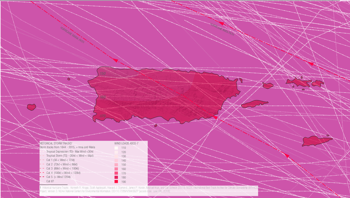
High winds are one of the main hazards caused by tropical cyclones, or “hurricanes,” in addition to flooding caused by storm surge and heavy precipitation. The highest wind speeds are near the center of the storm, or “eye,” so the wider the storm, the more places are hit by the highest winds. Tropical cyclones usually arise during “hurricane season,” from June 1st to November 30th, because they require a surface water temperature of at least 82 degrees Fahrenheit.
Wind speeds are used to classify events: tropical depressions (up to 38 mph), tropical storms (39-73 mph) and hurricanes (74 mph or higher), which are further divided into categories (‘Cats’): Cat 1 (75-95 mph), Cat 2 (95-110 mph), Cat 3 (111-129 mph), Cat 4 (130-156 mph), and Cat 5 (157 mph or higher).7
Exposure to high wind risks can vary depending on location, terrain, and other geophysical conditions. Open terrain has more potential for wind damage, but densely populated areas have the potential for more windborne debris.
- Soil in mountain areas can be destabilized, when high winds rip up trees and plants and precipitation saturates the ground.
- High winds cause damaged canopies, dead trees, and broken branches that in combination with other factors, such as drought and high temperatures, and increased fire risk.

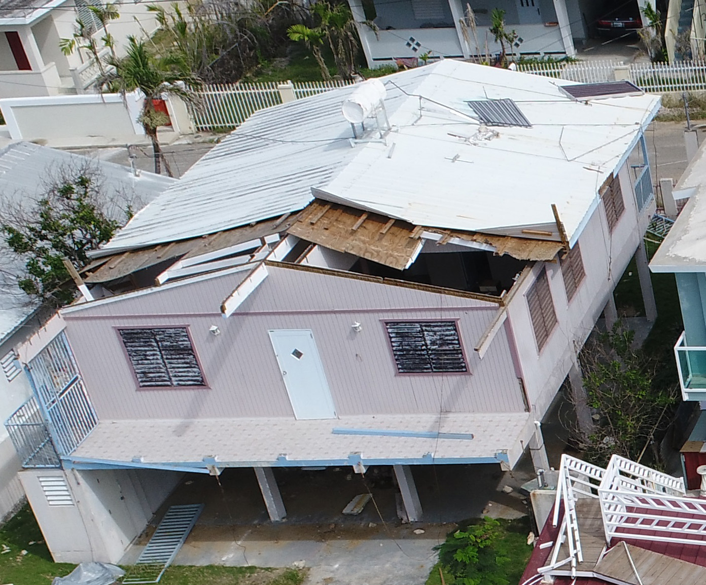
IMPACTS TO HOMES
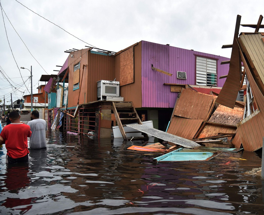
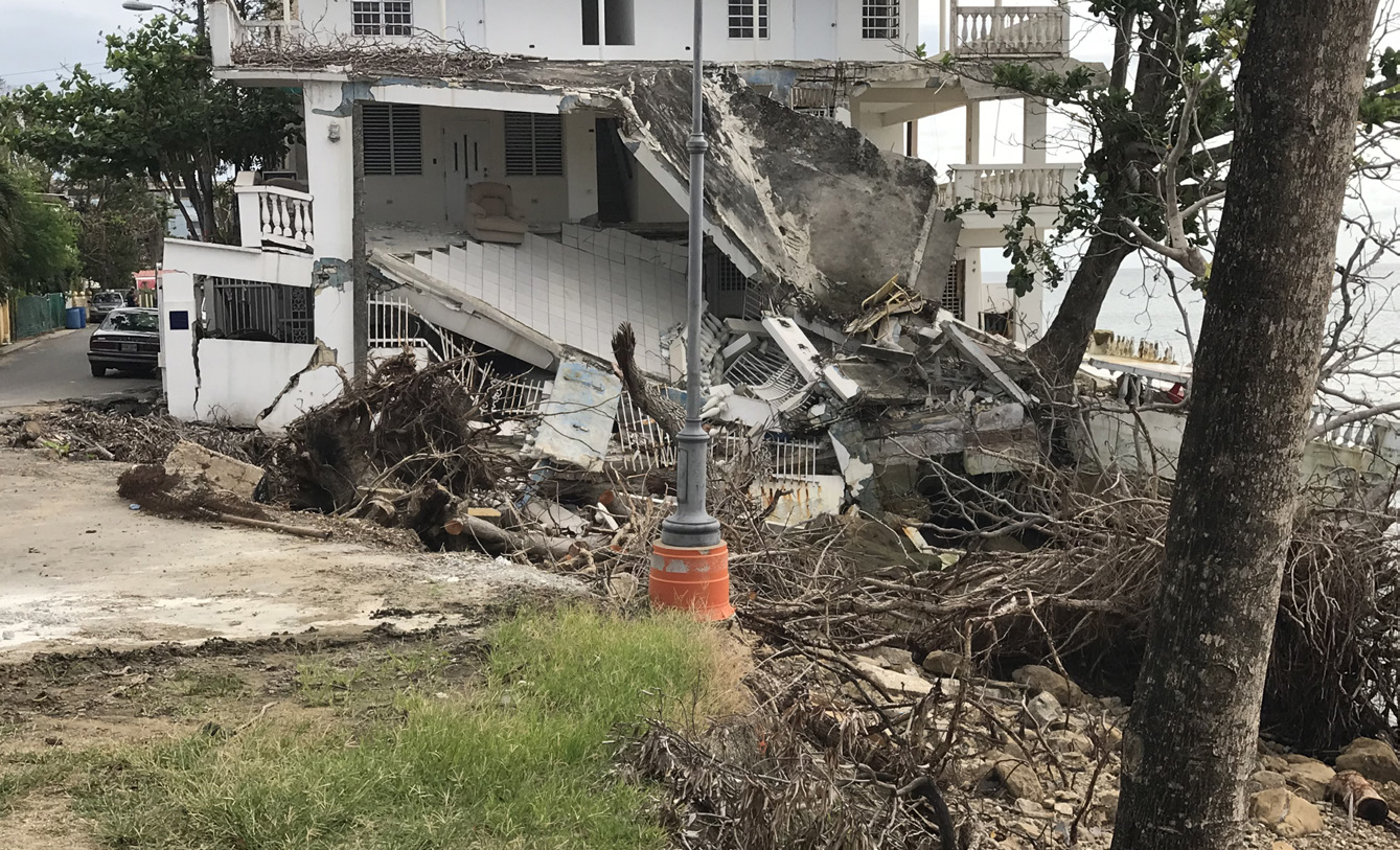
There are over 1 million housing units in coastal areas, and few have been fortified to withstand high winds, extreme rain or storm surge resulting from cyclones and hurricanes. Storm surge is propelled ashore by hurricane winds and will reach more properties as sea levels rise.
High Winds:
- High wind pressures and wind-driven rain cause fragile power lines to collapse, uproot trees, and lift debris and vegetation.
- High winds produce a large amount of debris that can perforate buildings. This brings wind-driven rain into the building, furthering water damage and allowing wind pressure to increase inside the house leading to structural damage.
- High winds destroy roofs, walls, windows, structural systems, and foundations.
- Driving rain damages windows and doors and lifts roofs from the inside.
- Flying debris turns unsecured objects, even large trees, into projectiles.
- High winds result in damage to foundations and overall structures, backed up sewage systems, shorts in electrical systems, ruptured containers of pollutants, and mold on surfaces and structures.
DROUGHTS
Droughts are caused by decreased precipitation, resulting in water shortage and related economic, environmental, and social impacts. It is likely that droughts will continue to intensify for the island as temperatures increase and precipitation decreases, with more frequent dry days. Dry season in Puerto Rico primarily runs from December to April, preceding the hurricane season. When drought occurs, underground aquifers are not replenished, lowering the water table. Lowering the groundwater table dries out the soil above it. When soil dries out, it causes the land to sink, leading to “subsidence” and instability.
- Drought affects vegetation in all regional locations and leads to food insecurity.
- Drought threatens the water supply, imperiling crops and people.
- Lowland moist forests dry out from drought or tree canopy loss from cyclones and become fuel for fires.
Impacts to Homes
- Droughts may reduce streamflows, lower lake and reservoir levels, deplete soil moisture and aquifer reserves, and diminish groundwater reserves, limiting potable water supplies for homes.
- Droughts limit water for farms and gardens.
- Dry vegetation increases fire risk, creating wind- blown embers, which are the main causes for the majority of structures that ignite in wildfires. Embers can be carried more than a mile through the wind, according to the National Fire Protection Association (NFPA).
Many homes are in areas adjacent to dense vegetation, referred to as the “Wildland Urban Fire Interface,” and are susceptible to fires and conditions determined by type and distribution of vegetation, the flammability of structures in the area, density of settlement, weather patterns, topography, hydrology, and road construction.
EXTREME HEAT
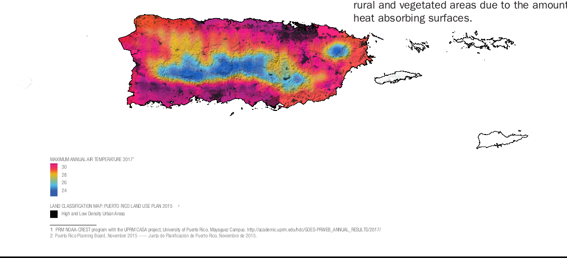
Extreme heat is a combination of increased temperature, high humidity, and evaporation that reaches 10 degrees or more above the average high for the region. Puerto Rico’s annual temperature (81 degrees Fahrenheit) has increased by over 1.5 degrees Fahrenheit since 1950. There will be more days of extreme heat and an annual temperature rise of 9.5 degrees by 2100.
Heat related illnesses are exacerbated by stagnant atmospheric conditions and poor air quality, making people who live in urban areas more vulnerable to the effects of prolonged heat waves than those living in rural areas. Extreme heat can also affect communities by increasing demand for more ventilation and cooling in buildings and dependence on electrical power. Increase in average temperatures can limit the time people spend outside, while also releasing more air pollutants, leading to poorer air quality and increased thermal stress on residents.
Impacts to Homes
Heat can affect housing significantly, especially since the modern home is dependent on mechanical cooling systems to keep occupants comfortable. Dark surfaces, common in developed areas, absorb heat from the sun and then radiate it out, creating hotter localized zones. Health risks grow for everyone; the longer the heat lasts, it is especially dangerous for vulnerable populations such as seniors, anyone with compromised health, asthma or other respiratory issues, children, and pets. Impacts to housing include:
- Increased demand for mechanical cooling systems, taxing the power grid and leading to blackouts.
- Increased demand for water, taxing the water supply.
- Increased health risks due to higher constant temperatures and hotter air, which can lead to cardiac and respiratory problems.
- “Urban Heat Island” effect: urban communities are exposed to higher temperatures compared to rural and vegetated areas due to the amount of heat absorbing surfaces.
WATER ( HYDROLOGIC )FLOODING
Flooding is an overflow of water that submerges areas that are usually dry. There are hundreds of water bodies in Puerto Rico, many of which are prone to overflowing their boundaries.
Flooding damages in Puerto Rico continue to escalate due to changing weather, bringing more rainstorms and greater sea level rise. Due to Puerto Rico’s rapid urbanization over past decades, watersheds are now covered with impervious surfaces (asphalt, concrete and roofing) that prevent infiltration of rainfall into the soil, thus disrupting the water cycle. The Puerto Rico Planning Board, together with FEMA, estimates that 252,748 structures throughout the island face the risk of flooding. Excessive rainfall coupled with housing located in flood plains, unpaved roads, and steep slopes exacerbates erosion rates and has adverse effects on reservoir capacity, water quality, and nearshore marine habitats.
Heavy rainfall and extreme storms also trigger frequent landslides. Puerto Rico is highly susceptible to landslides due to its mountainous terrain, especially in rural areas where vulnerable construction on hills and slopes is more common.
There are several types of flooding and exposure will differ depending on the location. Types of flooding include:
- Inland flooding which can occur through downpours over a short period of time or during extended periods of rain. Inland flooding or “urban flooding” can be caused by infrastructure failure (e.g. when sewer lines get clogged) or extreme precipitation.
- Flash flooding which builds up quickly, often in urban areas, where there are impervious surfaces or sewer systems that prevent water from draining.
- Riverine flooding that occurs when rivers overflow due to precipitation, runoff from higher areas, and if near the coast, storm surge, coastal, and tidal flooding. Riverine flooding causes erosion of riverbanks, fills reservoirs and other infrastructure with silt, and prevents sufficient water from being both stored and distributed. Valleys are hit hardest by inland and riverine flooding from rain, which can cause landslides from unstable terrain.
- Tidal flooding that can result from normal tidal variations of sea levels. As seas rise, tidal variations will push further inland.
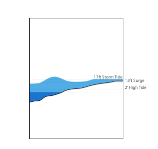
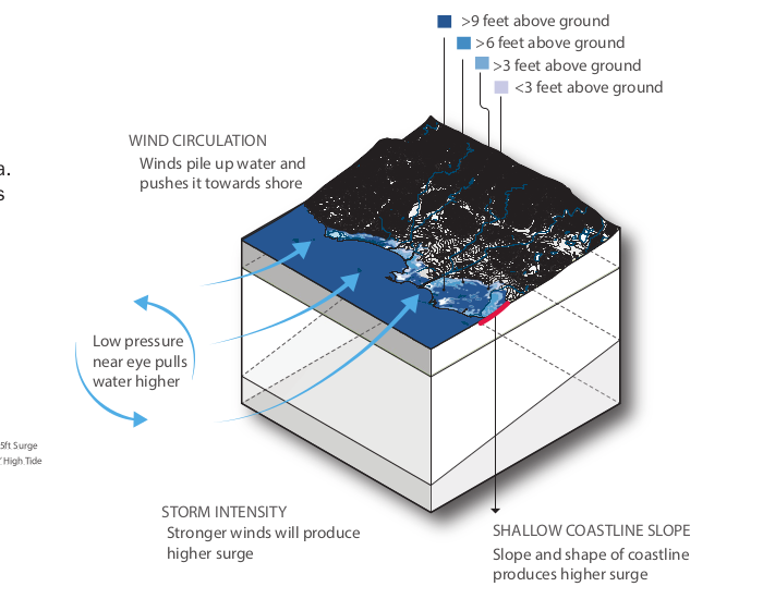
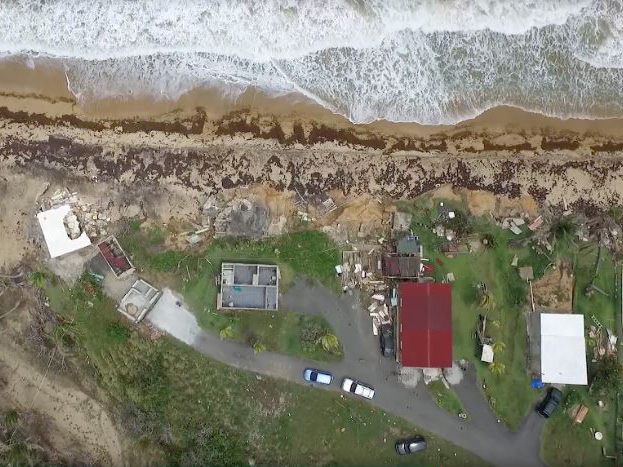
- Coastal flooding and “storm surge” which is the inundation of coastland, primarily due to storm surge in coastal areas. Storm surge, known in Spanish as marejadas ciclónicas, is a rise in water levels generated by a storm, over and above the predicted astronomical tides. This rise in water levels can cause extreme flooding in coastal areas, particularly when storm surge coincides with normal high tide, resulting in storm tides reaching up to 20 feet or more in some cases. Sea level rise will continue to amplify the impacts associated with coastal hazards, including storm surge.
- Coastal erosion is loss of coastland when waves and currents remove sand from the beach. Coastal zones experience the highest and strongest direct storm surge and resulting flooding and erosion.
- Storm Surge flooding:
- Scours the ground and homes with wave action, often ripping the ground level of buildings apart, causing more damage than wind or flooding alone.
- High-energy wave action may cause shorelines to recede inland and sites to disappear.
Flooding can lead to:
- Health problems from exposure to polluted floodwater
- Standing water that exposes residents to vector- borne diseases
- Breached infrastructure such as dams and levees, which cause further damage
- Damage to structural systems in wood-frame buildings
- Damage to electrical and plumbing systems
- Loss of interior finishes and home contents
- Growth of toxic mold
- Release of hazardous household chemicals or fuels
- Erosion of landscape around homes
Impacts to Homes
Models predict that Puerto Rico’s total coastal land area will shrink by 3.6% by 2100 and create substantial issues for all property owners. Over 92% of coastal municipalities recorded a loss of their shoreline, which translates into loss of community land for housing, associated infrastructure, and local economy, leaving coastal properties even more vulnerable to future disasters.
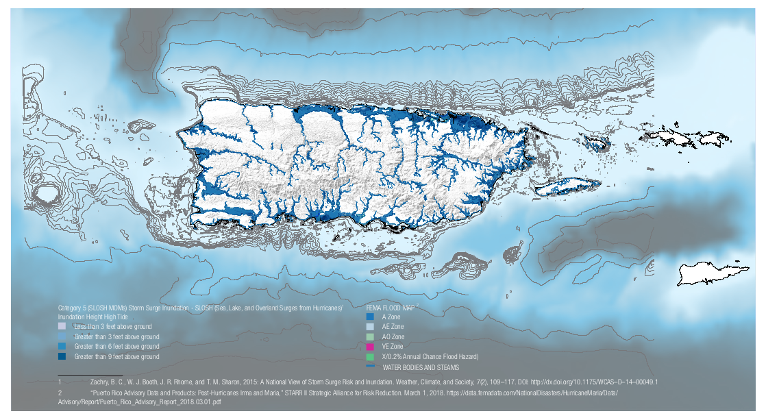
FEMA creates flood maps with boundaries of risk. Find out what zone you live in to understand your flood risk: https://msc.fema. gov/portal/searchDefining FEMA Flood Zones
 |  |
LAND ( GEOLOGIC )EARTHQUAKES
Earthquakes are caused by the release of energy accumulated within or along the edges of the earth’s tectonic plates where seismic waves radiate around the origin epicenter and cause the ground to shake. Earthquakes are sometimes followed by tsunamis and land-deformation processes such as liquefaction, landslides and subsidence:
|  |
Puerto Rico Earthquake & Social Vulnerability / Preliminary Damage Assessment
IMPACTS TO HOMES
- Earthquakes increase ground instability and frequently cause buildings to collapse from structural and other property damage. The greatest damage occurs when buildings are located on unconsolidated sedimentary rock, especially when it is saturated with water or when groundwater is high. Structures of unreinforced masonry are at great risk and vulnerable to smaller quakes than buildings built to current seismic codes (2018 International Building Code).
- Subsidence
- Leaves foundations less secure
- Increases risk of flooding in low-lying areas
- Increases the rate of sea level rise because the ground is lower and may also allow for higher water tables and coastal surges
- Landslides
- Topple homes built on unstable soil, burying anything they fall upon
- Disrupt road access and prevent emergency crews from providing rescue, provisions, or repairs
- Prolong danger after rains and earthquakes, when unstable conditions exist but are not visible
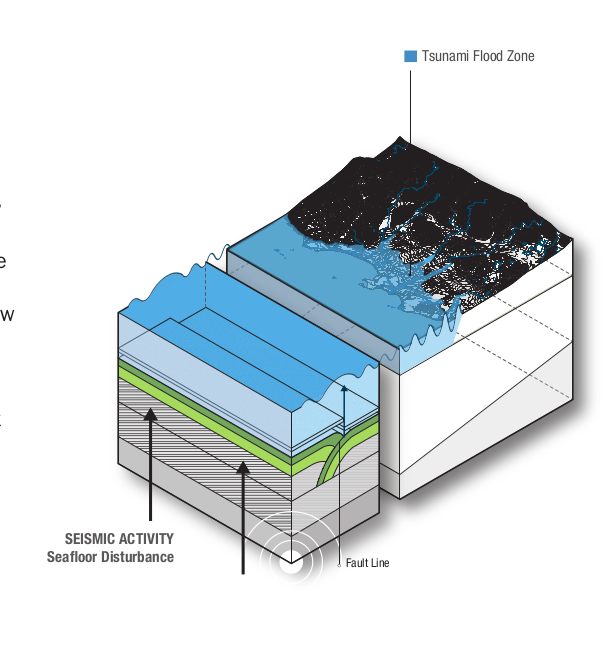
- Earthquake-induced tsunamis
- Destroy buildings and infrastructure with high- energy wave action
- Spread debris over large areas
- Cause dramatic coastal erosion
- Bring with them debris that magnifies the damage to structures in its path
- After any seismic event, land may not be safe to rebuild on. Get homes inspected to ensure structural safety.
| Fact: There are few land areas or islands to block a tsunami generated near the Puerto Rico Trench from entering the Atlantic Ocean. At the larger scale, certain land management strategies can be applied. For example, wave energy from tsunamis may be reduced 75% if the waves pass through 200 meters of mangroves. . It has also been found that 1.5km belt of mangrove may be able to reduce a wave one meter high (Mazda et al. 1997). | 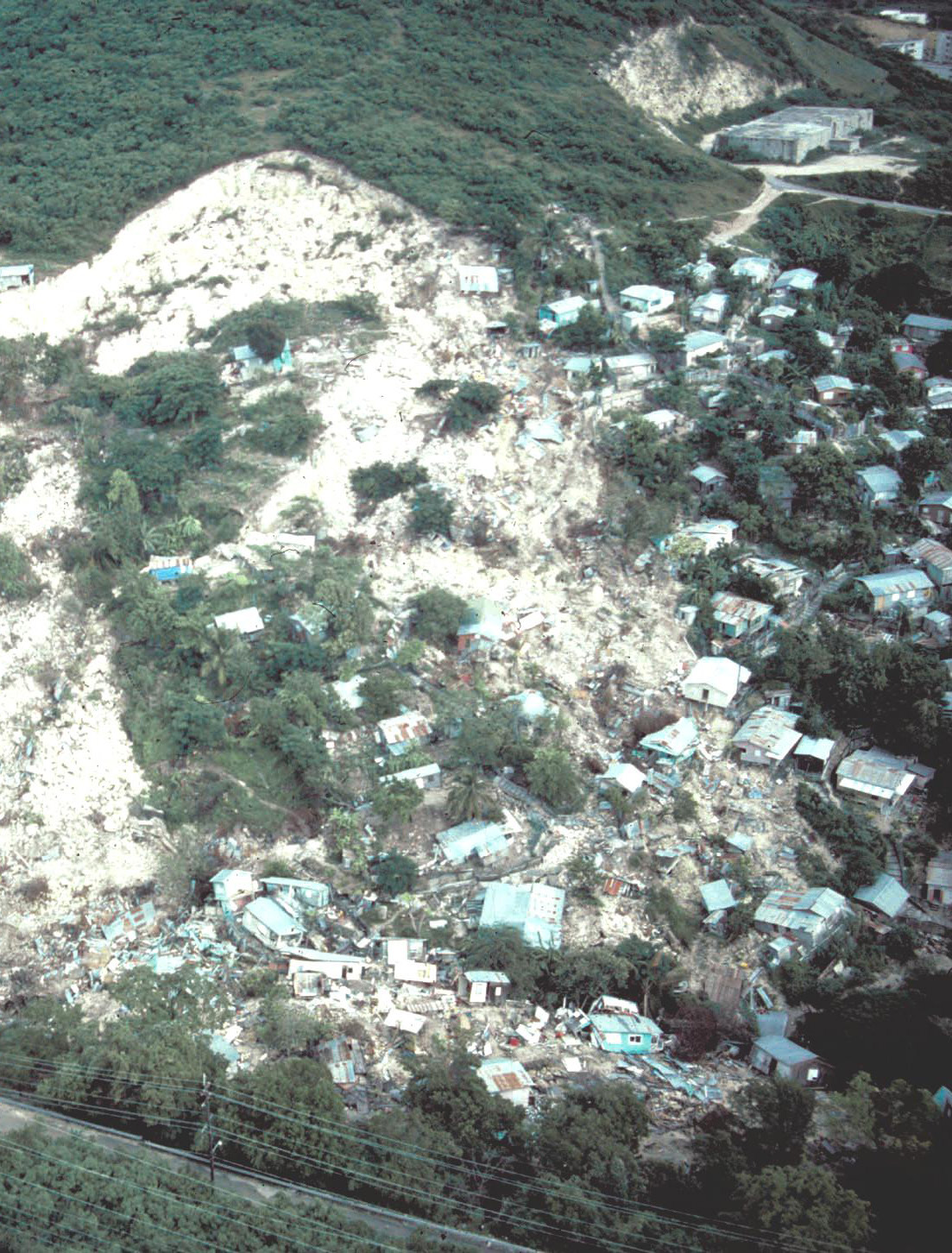 |
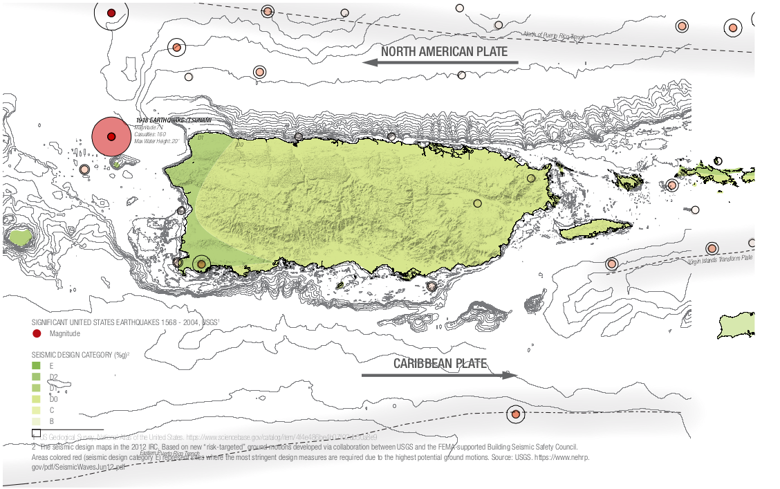
THE PUERTO RICO TRENCH
| The Puerto Rico Trench is the deepest part of the Atlantic Ocean and the Caribbean Sea at just over 8,600 meters (5.3 miles). The Puerto Rico Trench marks the boundary between two tectonic plates, the North American and Caribbean plates. The North American Plate moves west-southwest relative to the Caribbean Plate and subducts (slides) beneath it. The Puerto Rico Seismic Network detected 3,947 earthquakes in 2016. | 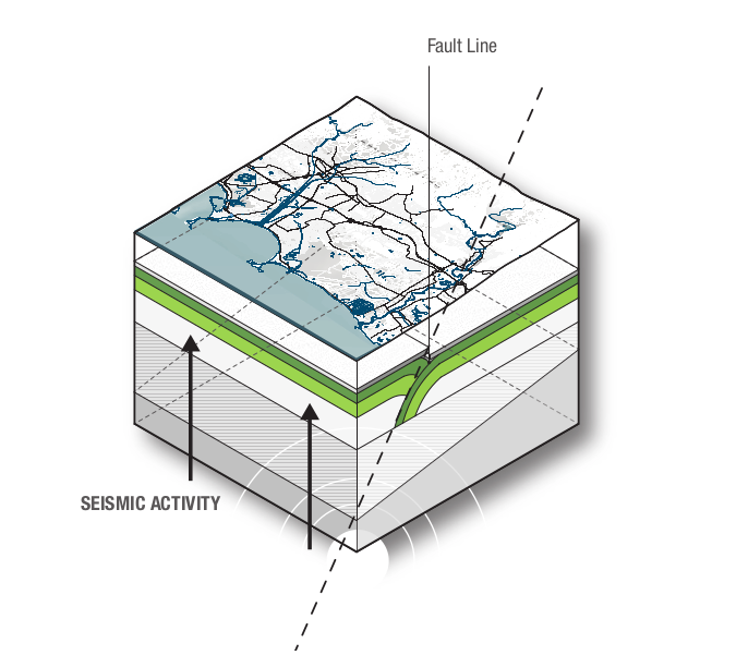 |
It cannot be emphasized enough that awareness and education build resilience and help prepare for and reduce the impact of future hazards. In most cases, lessons learned through past disasters have been the main catalysts for advancing change and knowledge, both in the general population and in public policy. A combination of environmental, economic, social, cultural, and political factors allow events like Hurricanes Irma and Maria to inflict additional damage, affecting the Puerto Rican economy, environment, and society. Understanding the socio-economic and political context of a disaster builds a comprehensive view of the impact it has on the island at the time and what can be done moving forward.
It is important to examine disastrous events in the past to understand how devastating natural hazards can be on Puerto
Rican communities. Land use patterns and the development of the built environment are critical towards determining risk exposure, but socio-political and economic processes also influence inequitable exposure to hazards and unequal access to protection. The following comparative retrospective examines the lessons learned from eight main historic events and provides a better understanding of the current and future disaster landscape of the island, especially in how these events have led to changes at different scales—from how people and communities prepare and respond to disasters to how they have triggered changes in policy at different levels of government. These events highlight how people see, understand, and remember risks, serving as a map of Puerto Rico’s collective memory regarding natural disasters.
1899 THE SAN CIRIACO HURRICANE
The San Ciriaco Hurricane happened in 1899, just as Puerto Rico was transitioning from Spanish to American control, influencing hurricane response and contributing to the poverty, political instability, and lack of comprehensive relief at the time. It was considered the deadliest natural disaster in Puerto Rico’s history, surpassed recently by Hurricane Maria. More than 3,300 people died in the floods and 25% of the population were left homeless. Twenty-eight consecutive days of rain were recorded and winds reached 100 mph. Most of the cultivated crops were destroyed, including more than half of the sugar crops, but the coffee plantations in the mountains were the most impacted. This lead to severe social and economic difficulties in Puerto Rico for years to come. The storm surge that entered the area of Humacao reached at least 15 feet in height, reaching one mile inland.
This event established disaster relief processes on the island under US military protocols. The new Weather Bureau was established to collect detailed information.
1918 SAN FERMÍN EARTHQUAKE AND TSUNAMI
The epicenter of this earthquake was located about 35 km from Aguadilla on the northwest coast of the archipelago. It measured 7.1 ML on the Richter scale and was followed by a tsunami five minutes later where waves reached a height of 20 feet. San Fermín caused the most damage in Mayagüez and neighboring cities, resulting in 116 casualties, over $4 million in damages, and leaving more than 10,000 people homeless. River currents from backflowing estuaries demolished bridge foundations resulting in collapsing infrastructure, severed underwater telegraph cables, disrupted communication systems, and triggered mudslides. Most of the property damage was located in Aguada and Añasco, where a lot of the masonry, brick buildings, and structures with little reinforcement were damaged. Liquefaction was observed during the earthquake as well as cracks in the low lying grounds, especially in the cane fields in western Puerto Rico.
A Special Earthquake Commission was established after the event, and continues to monitor the probability of major earthquakes today. Their 1919 Technical Reports gave general recommendations for seismic resistant buildings. Other important documents were produced as a consequence of the 1918 event, including recommendations by the U.S. Army Corps of Engineers and the Commissioner of the Interior to revise the Building Regulations in Puerto Rico.
1985 LANDSLIDE OF MAMEYES
The landslide occurred during extreme rainfall from Tropical Storm Isabel, which produced 70 mm of rain in an hour and triggered a rock-block slide that destroyed most of the Mameyes residential area northwest of Ponce. Other contributing factors in the slide included sewage saturating the ground in the densely populated hillside neighborhood and a leaking water pipe at the top of the landslide. The Mameyes landslide destroyed/damaged over 200 homes and killed at least 129 people, which resulted in the largest death toll from a single landslide in North American history. The event highlighted Puerto Rico’s housing shortage and the need for more low-cost housing. After the landslide, the Governor ordered a study of the informal communities located in “high-risk areas” where people would be notified of the risks and given assistance to move elsewhere.
The Isabel storm floods and landslides of 1985 prompted federal agencies to make comprehensive evaluations (Federal Interagency flood hazard mitigation team response report for Puerto Rico, 1985) and also generated demands for landslide study and policy changes, including zoning.
1986 FIRE AT DUPONT PLAZA HOTEL
The Dupont Plaza Hotel in San Juan suffered a major fire on December 31st of 1986. This building was located at the central Ashford Avenue in the Condado area, one of the most exclusive tourist areas in the capital city. The fire was started by three members of the Unión de Tronquistas of Puerto Rico. In the fire, the basement, lobby, and casino were destroyed in the flames and a total of 97 citizens died; another 140 were injured. More than 165 people had to be rescued from the rooftop of the hotel and transported to the nearest beach. It took almost 6 hours for firemen to extinguish the fire.
This event at the Dupont Plaza hotel exposed the lack of equipment and readiness for fires. After the tragedy, legislation was passed to require that public and private multipurpose buildings have automatic sprinklers and smoke detectors.
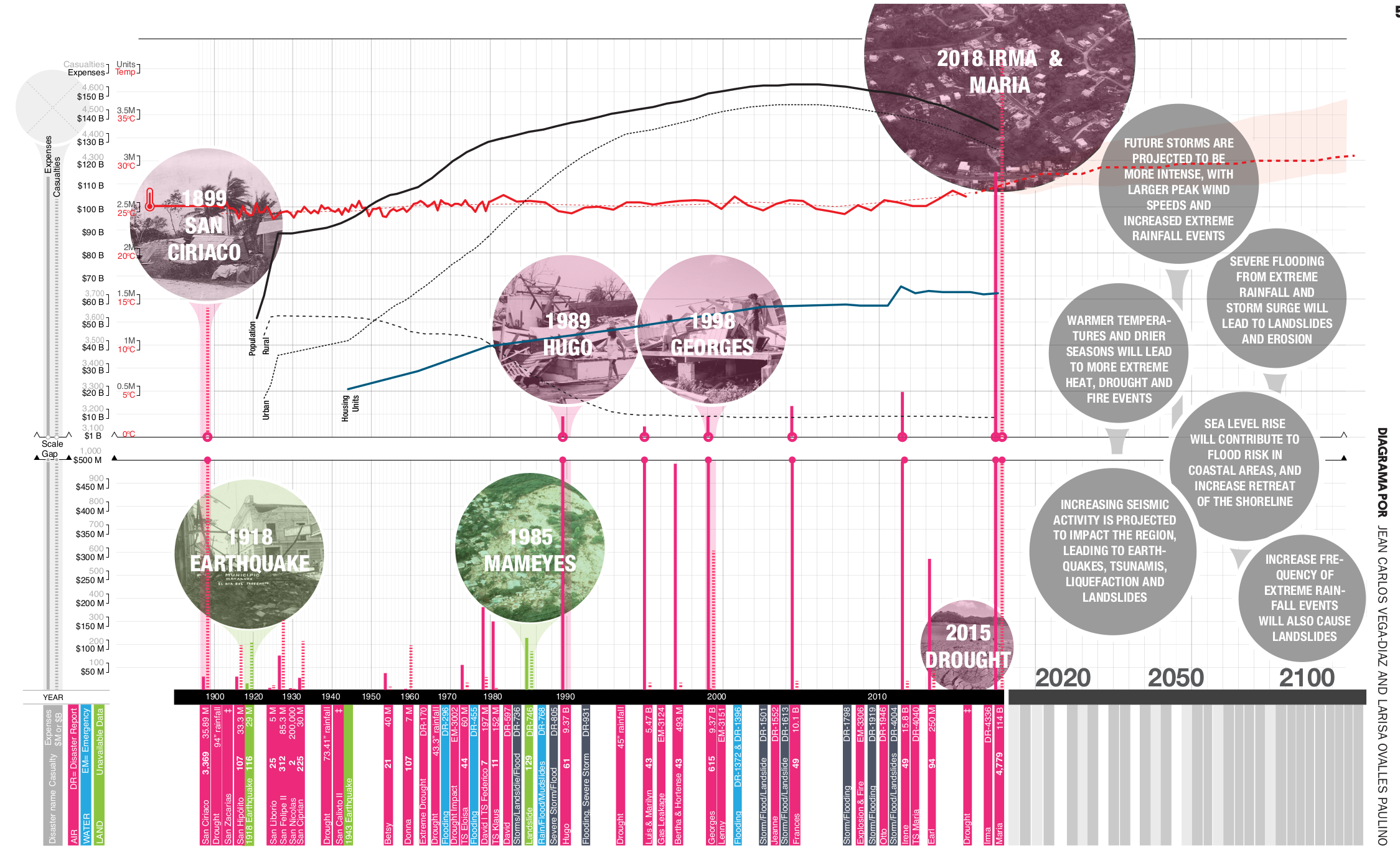
1989 HURRICANE HUGO
Hurricane Hugo made landfall in Puerto Rico on the southeast coast as a strong Category 3 Hurricane. Until 2016, Hugo was catalogued as the most intense tropical cyclone, claiming 24 casualties in South Carolina and 34 fatalities in the Caribbean, including Guadeloupe, St. Croix, and Puerto Rico. With a total cost of 9 billion, it was the most harmful hurricane to make landfall in the US at the time. The storm also triggered landslides in eastern Puerto Rico, which led to guidelines determining landslide risks based on slope hazard evaluations.
After Hugo, a hurricane storm tide atlas was published for the affected eastern municipalities of Yabucoa, Humacao, Fajardo, Naguabo, Ceiba, Luquillo and Rio Grande (Post, 1994), and an evaluation of the Puerto Rican experience regarding the NOAA storm surge model (SLOSH) managing coastal hazards. Post-Hugo, federal preparedness documents targeted hurricane-resistant building guidelines (FEMA, 1989).
1998 HURRICANE GEORGES
Georges reached Category 4, causing 8 casualties and around $2 billion in losses. It caused the most damage to the agricultural sector, losing 75% of the coffee crops and 95% of the plantain and banana crops. A total of 28,005 homes were destroyed and 72,605 were damaged. By 1998, Puerto Rico was following a combination of local Codes and Permits (ARPE) standards and the Uniform Building Code standards for designs able to withstand 125 mph winds in residential structures. In 1999, the Puerto Rico Emergency Management Agency (PREMA) was created. Post-Georges, federal construction guidelines addressed one and two family dwellings in hurricane and seismic zones.
US and Puerto Rican officials prepared a plan that forbid rebuilding in areas that were risk-prone or in need of assessment. With the failure and collapse of significant Puerto Rican structures, Hurricane Georges’ impact on the built environment set a building code optimization precedent.
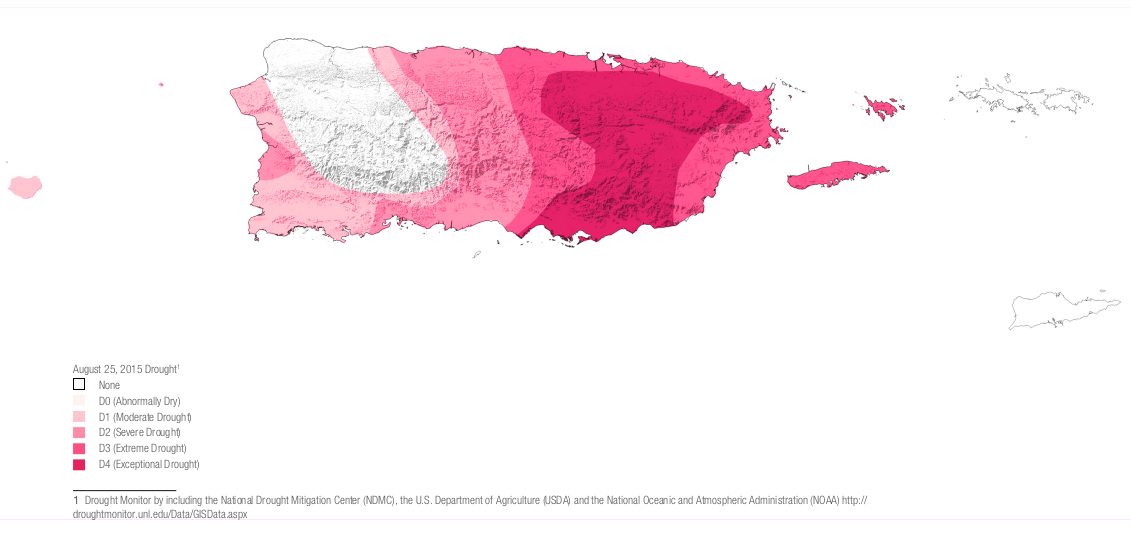
2014-2016 DROUGHT
The drought experienced from 2014 to 2016 was the worst in the Caribbean in at least 66 years. The National Drought Mitigation Center (NDMC) declared extreme and severe droughts in Puerto Rico. By 2015, more than 1.5 million people were affected by the drought. Summer water and ice deliveries were rationed and available in public places. Some areas would have water available every 24 hours up to 48 days. The drought dried up pastures and resulted in falling milk production as well as declining mango and plantain crops. The farming and tourism sectors suffered the greatest economic loss.
The drought experienced from 2014 to 2016 was the worst in the Caribbean in at least 66 years. The National Drought Mitigation Center (NDMC) declared extreme and severe droughts in Puerto Rico. By 2015, more than 1.5 million people were affected by the drought. Summer water and ice deliveries were rationed and available in public places. Some areas would have water available every 24 hours up to 48 days. The drought dried up pastures and resulted in falling milk production as well as declining mango and plantain crops. The farming and tourism sectors suffered the greatest economic loss.
As drought is now considered one of the greatest threats to Puerto Rico, food security is becoming a preparedness priority.
2017 HURRICANE MARIA
With loss estimates of over $90 million, Hurricane Maria was one of the most costly disasters in United States history. It also emerged as one of the deadliest on record.
The death toll attributed to Maria was 64 right after the storm, but this was ultimately raised to around 3,000. A new modelling method was developed to include people whose lives were shortened by the stress of the storm. The true costs of vulnerability can now be reflected more accurately.
Fernando Abruña holds a Bachelor’s in Architecture and the Master of Architecture from the Rhode Island School of Design and Pratt Institute of Technology respectively. He completed a non-traditional Doctor of Design Science Degree in 1977 at the age of 25 as an apprentice to Richard Buckminster Fuller from the International College in California. Dr. Abruña is a licensed, practicing architect, a retired professor of the School of Architecture, University of Puerto Rico, and Fellow of the American Institute of Architects. He is also the Founding and Past President of the U.S. Green Building Council, Caribbean Chapter, and the publicly recognized authority in Sustainable Design in Puerto Rico.
Abruña is the author of local best-selling green design and construction books including Fresco Gratis (touching upon the subject of passive cooling systems) and ¡Casas! (which was published by the Institute of Puerto Rican Culture). He is the Founder and 1st Director of the Sustainable Design Studio at the School of Architecture, University of Puerto Rico. Abruña practices his profession with his wife, Architect Margaret Musgrave, a Color Consultant and a licensed Green Realtor in charge of Interior Architecture for the firm. Abruña & Musgrave, Architects’ office is located in a two-hundred-year-old building in the historic city of San Juan, Puerto Rico.
Fernando Abruña 2/18/2019
What inspired you to initially invest in this movement for design and construction?
Before studying architecture, I was majoring in psychology. I remember walking with a friend at the University of Puerto Rico when I saw a tree casting its shadow against a street gutter. I saw this beautiful and contrasting conjunction between natural and man-made systems: the gutter as an expression of technology and the flickering shadow of the leaves of the tree so beautiful, moving with the wind against the sunlight. This was an epiphany, I said to myself this is something special and important. I told my friend “let’s go back to the library, I would like to see some catalogues on architecture schools”. There, I looked at a few catalogues and the one that caught my interest was Rhode Island School of Design’s (RIDS) catalogue. I eventually graduated from RISD where I did my research on natural ventilation; the school was so interested in the idea that they supported my building of a wind tunnel and a room to conduct my research. My first book, Fresco Gratis, was written in 1980 and based on this research. Then I went on to demonstrate and manifest those ideas in the world through design, building, publications, and education.
The word ‘resilience’ comes from the structural principle of a material coming back to its original condition once a load is taken off. People come up with new definitions every day. The way I define it is as how a living space is designed to survive catastrophic (including climatic) events through ‘Feasible Redundancy.’ Redundancy in systems makes for better resiliency in the built environment since it allows you to survive. If a first system fails, a second system comes into play. If the second system also fails, a third system takes its place. The challenge, as I see it, is how to make this redundancy economically and socially feasible and hence the term ‘Feasible Redundancy.’
Resiliency depends hugely on maintenance; more important than the concepts of sustainability and resiliency is MAINTENANCE, especially in Puerto Rico where the catastrophic force of Hurricane Maria greatly impacted systems that did not have the benefit of appropriate maintenance in place. Whenever a system is designed, its maintenance needs to be planned for and carried out. Recurring funds and user involvement to assure maintenance are essential for resiliency and sustainability to function properly.
What challenges did you encounter as you created these models?
When I started working on these ideas within the design and construction industry, energy, materials, and resources were cheaper. Energy was so cheap that people would not consider natural ventilation, daylighting, and passive strategies because it was relatively cheap to do it the wrong way. The Oil Embargo of 1973 caused, in my view, a technological and cultural shift where people began to appreciate nature, sustainability, and resilience as potential solutions to the challenges brought about by the built environment and its effect on nature. In the beginning, it was the forces of counterculture that brought this discussion to the forefront. I became a tree hugger; I knew cutting down trees was not a trivial issue because of the inherent benefits that come from having them around. I knew it was wrong, but I could not justify it with rational arguments. My approach was visceral. Later on, corporate institutions started adopting these ideas and started assessing the impact of the systems and attributing scientific metrics to the work to measure that impact. The challenge at that time, when I began doing this, was that the metrics were not there. Now, with scientific metrics, you can argue not to cut a tree because it will, for example, cost you more for air conditioning, water retention, etc.
Another challenge is the risk factor and which communities are going to be on the front line in climate change and its consequent displacements. The place where you are born is such a significant piece of your own soul. Some communities face more challenges than others depending on their resources. The costs of things are skyrocketing. Building in flood prone areas is going to be costlier than going to a new place. But if we talk about the relocation of communities, we need to talk about well-off communities like Ocean Park as well as economically challenged and depressed communities like those bordering the Martín Pena Channel. If you are going to talk about relocating communities, you need to do it across the board and not just the communities with lower incomes, which are typically the more exposed and vulnerable communities. There cannot be any exceptions. The same relocation argument is happening and will continue to rise at a global scale. Imagine a foreigner, say from Switzerland, building an argument for all Puerto Ricans to move from the island because we are in the annual path of hurricanes, it makes some sense…but would all Puerto Ricans agree with this idea? Vulnerable communities also face the same challenge in flood prone areas. It is a difficult issue that needs more discussion. Ultimately, Nature will make the final decision, if we, as a society, cannot come to an equitable agreement between us all.
What lessons have you learned from Maria and what do we need to invest in?
The government issued recovery funds that need to be well-managed. There seems to be a speed frenzy as to how to spend this money. We need to move slower in order to make sure we spend it correctly, in the right places, and above all making maintenance the priority in that plan. The eyes of the world are on Puerto Rico. What we do will be carefully observed and studied by many other communities around the world. Puerto Rico is now living the future, which other regions in the world will be facing in theirs.